By Chan Kok Leong
Almost one week after Malaysia Airlines Flight MH370 disappeared, its whereabouts hinges upon an unidentified "plot" recorded a week earlier and satellite "pings."
But the radar plot recorded by Malaysia’s military's primary radar remains unidentified and the search’s expansion into the Indian Ocean is premised upon an educated guess at best.
“The Royal Malaysian Air Force (RMAF) had on Saturday suggested there could have been a turn back by MH370 but we are not 100 percent sure yet,” acting Transport Minister Hishammuddin Hussein told reporters Friday.
"When I alluded earlier to expanding the search (beyond the Straits of Malacca and Andaman Sea to the Indian Ocean), this is because we haven't found any new information," he added.
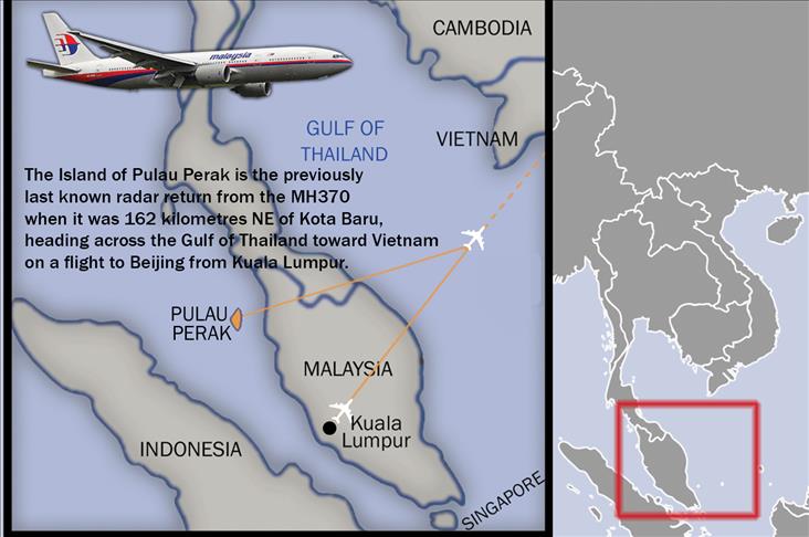
On Wednesday, RMAF chief General Rodzali Daud confirmed that a military radar had detected a plot heading west of Peninsula Malaysia at 2.15am (local time), some 45 minutes after the Boeing 777-200ER was last detected on the eastern borders of the peninsula.
The plot was seen 200 nautical miles northwest of Penang heading towards the Indian Ocean or Andaman Sea, while the plane was originally headed towards Beijing, China. Penang is an island located on the northwest of Malaysia in the Straits of Malacca.
According to Hussein, Federal Aviation Authorities and the National National Transport Safety Board are “now looking at the raw data” and he would announce it immediately once they could verify the information.
Media reports, quoting sources familiar to the investigations, said that current analysis of the radar data suggests that the plane flew west towards the Middle East and Europe.
"Two sources said an unidentified aircraft that investigators believe was Flight MH370 was following a route between navigational waypoints (aviation corridors N571 and P628) when it was last plotted on military radar on the country’s northwest coast," said a Reuters report.
Quoting a third source, the report said the probe was now focusing on the theory that someone deliberately switched off its communication systems and diverted the flight.
In a more detailed revelation, the first two sources said that the last confirmed position of MH370 was at 35,000 feet. about 90 miles off the east coast of Malaysia, heading towards Vietnam near a waypoint named “Igari” at 1.21am.
The military track said it then turned sharply westwards towards another waypoint called “Vampi” or aviation corridor N571, northeast of Indonesia’s Aceh province.
After that, the plot showed that the plane flew towards another waypoint called “Gival,” south of the Thai island of Phuket before moving northwest towards waypoint “Igrex” or route P628.
In a separate development, unnamed U.S. military and space industry officials told the Wall Street Journal satellites had detected electronic pulses from MH370.
The report said that “five or six pings were detected before the pulses disappeared.”
The minister, however, declined to comment when asked whether the Malaysian side was aware that pings had been found by an American satellite.
This morning, American warship USS Kidd was deployed by the Pentagon to conduct searches in the Indian Ocean while USS Pinckney has ended its search and will head to Singapore for maintenance.
Malaysian Airlines flight MH370 went missing after losing radio contact with the Malaysian and Vietnamese air traffic control after leaving Kuala Lumpur International Airport on March 8.
The Beijing-bound flight was carrying 239 passengers including 12 flight crew from 14 different countries.
englishnews@aa.com.tr


